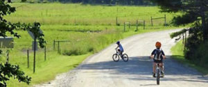
Explore the quieter sides of town, with fields & farms, views of our serene shoreline & historic settlements – all from a bike! Road conditions are generally good. Cautions: Moderate traffic & narrow roads. Some roads have no shoulders. Please observe all safety measures & bicycle at your own risk. All distances listed are for one way.
 Wolfe’s Neck: 4.8 miles. This route will take you past Wolfe’s Neck Center & to the shore. Directions: From downtown take Bow St (directly across from L.L.Bean) which becomes Flying Point Rd. Follow for 3.5 miles. Make a right onto Lower Flying Point Rd. (Watch for campground signs) Take the next right on Burnett Rd, which is a mostly hard-packed dirt road. Option 1 – Make a loop back to town (+4.6 miles): Continue past Wolfe’s Neck Center & follow Burnett Rd across the little bridge & to the end about .5 miles. Make a right onto Wolfe’s Neck Rd for about 1.5 miles back out to Flying Point Rd. Make a left & follow back into town. Option 2 – Wolfe’s Neck Woods State Park: Continue past Wolfe’s Neck Center & follow Burnett Rd across the little bridge & to the end about .5 miles. Make a left onto Wolfe’s Neck Road. In a few feet make another left into the state park. (fee)
 Bradbury Mountain State Park in Pownal: 5.8 miles. An inland route to Bradbury Mountain in neighboring Pownal past farmland & fields. Directions: From downtown go north on Main St/ Route 1 about 0.5 miles to traffic light. Turn left onto Rt 125 N/Rt-136/Mallet Drive. After crossing the I-295 bridge, follow signs for Bradbury Mountain & make a left turn onto Pownal Rd. Bear right up the hill at the sharp corner & continue about 3.5 miles to Route 9 at Pownal Center. Turn right on Route 9 for 0.5 mile to the top of the hill & make a left at the sign. (fee) Option 1- Make a loop (add about 11 miles): At Pownal Center, take Route 9. In about .5 mile take a left onto the mostly hard-packed dirt Loring Lane. In .5 mile take the first left onto Hodsdon Rd. In another .5 mile take the first right onto Merrill Rd., & continue on it for about 4 miles (it becomes Hunter Rd) Turn left onto Desert Rd & follow over the I-295 bridge, bearing left through the traffic lights, north on Lower Main St/ Route 1 to downtown.
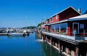 South Freeport Waterfront: 2.5 miles. A fun ride to our harbor & historic South Freeport. From downtown take Bow St. down the hill to just over the railroad tracks, & make a right onto South St. following for about 2 miles to the 4-way stop. Take a left onto South Freeport’s Main St,and continue to the end, 0.3 mile. Option 1 – Make a short loop (add about 3.5 miles) Coming up from the harbor, go straight through the 4-way stop, following Pine St. for about 1.5 miles. Take a right onto Route 1/Lower Main St. Bear right at the traffic light to continue on Route 1 into downtown, about 2 miles from the light. Option 2 – Make a longer loop (add about 5.5 miles) Coming up from the harbor make a left at the 4-way stop onto South Freeport Rd. Follow about 2 miles out to Route 1 at the Big Indian. Make a right & go north on Route 1 for 3.5 miles back to downtown.
 Desert of Maine: From downtown Freeport, head south on Rt 1/Main St about 1.5 miles to the intersection with Desert Rd. Bear right onto Desert Rd 2.3 miles, straight to the end! Option: Make a loop! Turn left out of the Desert of Maine driveway onto Merrill Rd & follow for 0.8 mile. Turn right onto Hunter Rd & follow for about 2.5 miles where you’ll meet back up with Desert Rd. Turn left to head back to town!
Rent a Bike: To rent a bike call Wolfe’s Neck Center, 207-865-4469