There are so many great places to hike in the Freeport area, it’s hard to distill them all to a top ten list! All sorts of hiking trails can be accessed right here in Freeport and in nearby towns. To find out more, look at the trail descriptions and trail maps offered by Freeport Conservation Trust. These maps will direct you to a dozen and a half trail heads for walks throughout town.
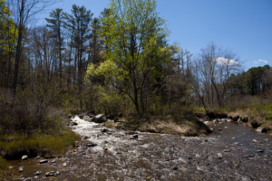
Maine Audubon Mast Landing Sanctuary
140 acres of diverse habitat and includes three miles of trails that wind along a stream and through orchards, fields and forest. The foundation of an old mill is visible where Mill Stream empties into the Harraseeket estuary. The name “Mast Landing” dates to the early 1700’s when the British Navy sought ship masts made from the massive white pines then growing in southern Maine forests. The sanctuary is open to the public, dawn to dusk, year-round. Dogs are not permitted. Directions: From Main Street in Freeport, follow Bow Street for one mile. Turn left onto Upper Mast Landing Road. The Sanctuary is just up the hill on the right.
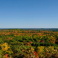
Bradbury Mountain State Park
Bradbury Mountain State Park is a wonderful place to spend a day or afternoon exploring trails, taking in the magnificent view from the summit, or enjoying a picnic under a canopy of trees. The park attracts visitors who enjoy picnicking, hiking and camping on its 800+ acres of forested land. Bradbury Mountain is the only state park in southern Maine to offer shared-use trails for horseback riders, mountain bikers and snowmobilers. Snow shoe rentals are available. Directions: From L.L.Bean take Main St./ Route 1 north to the traffic light. Take a left at the light onto Route 136/125/Mallet Drive. Shortly after the road crosses over the I-295 bridge, make a left onto Pownal Rd. & follow for about 4 miles. Turn right on Route 9 in Pownal, then left at the top of the hill at the Bradbury Mtn. State Park sign.
Cousins River Trail
This 0.6-mile trail passes over hills and boardwalks to the marshy shore of the Cousins River. Side trails lead to/from Lambert Road and the Best Western Freeport Inn and Cafe. Directions: The trailhead, marked by a kiosk, is located on a knoll at the back left-hand corner of the Casco Bay YMCA parking lot on Old South Freeport Road, off Route 1, south of downtown. Park in the YMCA lot.
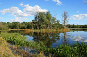
Florida Lake
The 167-acre property features a large, shallow lake and surrounding wetlands providing excellent habitat for a wide variety of birds, as well as beaver, deer and moose. From the parking area a flat path provides easy access to the lake. Hiking trails branch off the gravel path and pass through mature forests and by wetlands and streams. The trails can be very wet: boots and a sense of adventure are recommended. Dogs must be on-leash or under voice command at all times and pet waste must be carried out. Directions: From downtown take Main St./Rt 1 north to traffic light at Rt 136/125/Mallett Dr. Turn left taking Route 136/125 north of I-295. At the blinking yellow light, turn right onto Route 125 (Griffin Road) Drive 2.4 miles to a blue sign on the right.
Hedgehog Mountain
Hedgehog Mountain is a 196-acre property owned by the Town of Freeport. Over 5 miles of trails lead visitors up Hedgehog “Mountain” (the highest point in Freeport), through mature pine and hemlock forest, over and around old stonewalls. Hiking, snowshoeing, and cross-country skiing are allowed on all trails. Mountain biking and snowmobiling are allowed on designated trails. Dogs must be on-leash or under voice command at all times and pet-waste must be collected and carried out. Directions: From downtown, go north on Main St./Route 1. Turn left at traffic light onto Rt 136/125/Mallet Dr. After crossing I-295, take a left onto Pownal Rd. In about a mile turn left onto Hedgehog Mountain Road. A gravel parking area is located on the left just before the Recycling Center gate.
Hidden Pond Preserve
Hidden Pond Preserve is an easy 10-minute walk to the shore of the pond. Great spot for watching birds and other wildlife. Directions: From downtown take Main St/Rt 1 north to left at traffic light at Rt 136/125/Mallett Dr. Take Route 136/125 north of I-295. At the blinking yellow light, turn right onto Route 125 (Griffin Road.) In 4 miles take left onto Grant Rd. (across from store) The trailhead, a kiosk and a parking area are located on the left, approximately 0.6 of a mile from Route 125.
Leon Gorman Park
Gorman Park has a short (<.5 mile) loop trail, picnic tables, a covered picnic pavilion, a grassy area, and a small ice skating area. It is a lovely place for a quick stroll or picnic lunch and is within easy walking distance of Main Street. Some portions of the trail are very steep—strollers and bikes are not recommended. Dogs must be on a leash and pet waste must be collected and carried out. Directions: Just north of L.L.Bean turn right onto School Street. There is a small parking lot just after the 4-way stop, or continue to end onto Bow St., turn left, then take the first left into parking lot.
Quarry Woods
This 35-acre town-owned preserve has 1.5 miles of wooded trails that pass by vernal pools, an old apple orchard, and the site of the former E.B. Mallet granite quarry. Directions: Follow Bow Street from downtown Freeport, 0.9 mile turn right onto Lower Mast Landing Road. A trailhead is located approximately 0.3 mile south, on the right by a woodchip pile. During non-school hours, the Woods may also be accessed from Mast Landing School on Bow Street. At the back of the School parking lot, visitors should pass the pond to the left to find a trail.
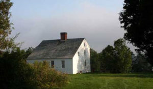
Pettengill Farm
Historic Pettengill Farm features 140 acres of woodlands and fields bordered by the tidal Harraseeket River. The site offers four walking trails of varying length and difficulty. Visitors are invited to enjoy the grounds dawn to dusk every day of the year. Dogs are not permitted. Directions: From Main Street in Freeport head down Bow Street for 1.4 miles. Turn right on Pettengill Road. Park by the welcome sign and walk-in to the farm, approximately 12 minutes.
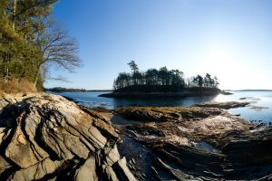
Wolfe’s Neck Woods State Park
A 233-acre state park dedicated to nature appreciation, the park provides interpretive signs on trails and guided programs for groups and the general public. Facilities include picnic tables with charcoal grills; wheelchair accessible parking, picnicking, bathrooms, and path; and five miles of hiking trails through the woods and along the shores of Casco Bay and the Harraseeket River. Directions: From downtown follow Bow St about 2 miles. Take a right on Wolf’s Neck Rd. In about 2 miles watch for sign & left turn into parking lot.